
Storm Austen Slams South-West England: 18,000 Homes Lose Power, Zoos and Holiday Parks Shut as 80mph Winds Batter the Coast

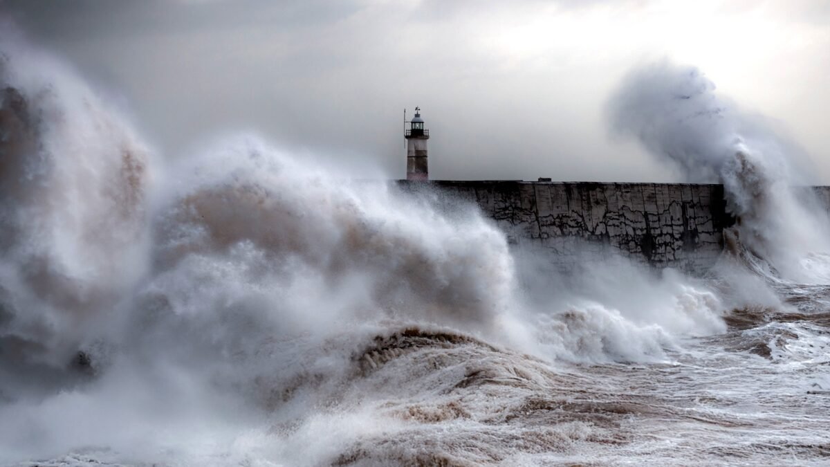
Storm Austen, the first named storm of the season, slammed into south-west England in the early hours of Friday, bringing gusts of up to 80mph, an amber “danger to life” warning, and a trail of disruption stretching from evacuated holiday parks in Cornwall to shuttered zoos, cancelled flights, fallen trees and a collapsed section of Brighton’s historic West Pier.
The storm, named by the Met Office on 20 October, arrived from the Atlantic as a rapidly deepening low and moved across the south of the country through Friday morning before clearing into the North Sea later in the day, according to the Met Office. It is the opening act of a stormy spell: the forecaster has already named a second system, Storm Boelo, which is expected to batter Northern Ireland, Scotland and northern England this weekend.
By Friday morning, the impact was already being measured in the tens of thousands. Nearly 18,000 homes and businesses were without power across England and Wales, according to National Grid — more than 13,000 of them in Cornwall alone. Eighty-seven schools in Cornwall either opened late or closed entirely, and travellers faced cancelled trains, suspended ferries and grounded flights.
Amber warning for the far south-west
The Met Office placed Cornwall, Devon, Plymouth and the Isles of Scilly under an amber wind warning from 3am to 10am on Friday, warning of gusts of 60 to 70mph developing widely, with winds of around 80mph possible on exposed coastal headlands. The warning text stated plainly: “There is a good chance that gusts of 60 to 70 mph will develop widely for a time with perhaps some gusts around 80 mph for exposed headlands. Very strong winds will be combined with spells of heavy rain.”
The amber warning carried the forecaster’s familiar catalogue of hazards: flying debris was “likely”, the storm would “probably” cause some damage to buildings — tiles torn from roofs — and in coastal areas, large waves and beach material thrown onto coastal roads and sea fronts could present a danger to life. Mobile phone coverage and electricity supplies could also be affected.
A wider yellow wind warning ran from midnight on Thursday night until 2pm on Friday across south-west England, south Wales, the south coast from Hampshire to Kent and Herefordshire, where gusts of 50 to 60mph were likely and more than 70mph possible on exposed coasts. A separate yellow warning for rain covered parts of Scotland from 6am on Friday until 3am on Saturday. The BBC reported that a yellow warning for 20 to 40mm of rain was in force, with up to 80mm accumulating in a few areas through Friday, and that heavy rain in Scotland could cause some localised flooding.
Across the Channel, the BBC reported that Guernsey and Jersey were placed under a red warning — the most serious level of alert — underscoring how severe the system was as it crossed the English Channel.
Met Office chief forecaster Neil Armstrong urged the public to take the warnings seriously as the storm approached Wales and south-west England. “This is the first stormy weather in the south of the UK this season and we expect some disruption as it moves through,” he said. “With trees in leaf, it is likely fallen branches and trees could obstruct roads and railways so take extra care on the Friday morning commute.” He also warned people to “stay away from cliff edges and well back from stormy seas that can sweep you off your feet”.
Met Office deputy chief forecaster Chris Bulmer said: “Storm Austen is expected to bring a spell of impactful weather to parts of the UK from Thursday night and through Friday. While there remains some uncertainty in the exact track of the storm, there is increasing confidence in the potential for disruptive winds across parts of southwest England, which is why an Amber warning has been issued.”
Power cuts, schools and the morning commute
The overnight winds did exactly the damage the warnings had described. National Grid reported that nearly 18,000 homes and businesses across England and Wales had lost power, with Cornwall bearing the brunt: more than 13,000 properties in the county were cut off as fallen lines and wind-borne debris hit the network. In Devon, around 1,000 homes were affected, and a primary school in north Devon — Horwood and Newton Tracey Primary School near Barnstaple — was forced to close because of a storm-caused power cut.
Education was disrupted across the region. There were 87 schools in Cornwall either opening late or closed entirely on Friday, while many schools in Plymouth opened later than usual to give parents and pupils on delayed buses extra time to reach them.
Roads were hazardous from the first light. The Torridge Bridge over the estuary at Bideford was closed in both directions because of high gusting winds, and drivers across the region were warned to drive with care as the weather dislodged stone and earth alongside roads, felled trees and left standing water on many routes. Motorists in Essex were photographed braving flooded roads, and in Cornwall, trees were ripped from pavements.
Travel chaos: trains, planes and ferries
Rail passengers in the south-west woke to a disrupted network. Cross Country services were cancelled between Plymouth and Penzance, while Great Western Railway warned that its services would not return to normal until later in the afternoon. Trains were suspended between Okehampton and Exeter because of the severe weather, with a replacement bus service laid on. In Bournemouth, rail services were disrupted after a train struck a tree that had fallen onto the track.
In the air, Guernsey-based airline Aurigny cancelled all of its services on Friday morning because of the weather, while passengers flying from Heathrow, Gatwick and London City airports were advised to check the status of their flights. Flights serving Exeter Airport were cancelled.
On the water, the Torpoint Ferry was reduced to a single-boat service because of maintenance, putting extra pressure on the Tamar Bridge, which was exposed to the strongest winds.
Zoos, holiday parks and heritage sites shut their doors
Some of Britain’s best-known attractions decided the risk was not worth it. Chester Zoo, Longleat Safari Park and Marwell Zoo in Winchester all announced they would close for the day, citing animal safety, while Maldon Promenade Zoo, Shaldon Zoo and Wildlife Park, Wildwood Devon and Dartmoor Zoo also shut. Newquay Zoo delayed its opening until 11am.
Chester Zoo said in a Facebook post: “With Storm Austen set to bring really strong winds, we’ve made the decision to close tomorrow (Friday 23 October) to help keep everyone safe.” Longleat said there was “a risk of lanterns and trees falling”, adding: “The safety of our guests, staff and animals must always come first.”
Holidaymakers were evacuated from coastal parks. Haven Holiday Parks asked guests to leave both its Perran Sands park in Perranporth and its Riviere Sands park in Cornwall as the storm bore down on the coastline, delaying new arrivals and offering those due on Friday a break at another park or a later arrival date. “We’re really sorry that people’s breaks are being disrupted but safety of our guests and team comes first,” a spokesperson said.
The National Trust closed venues across Devon and Cornwall, including Saltram in Plymouth, Buckland Abbey in Yelverton and Cotehele near Saltash.
One of the storm’s most striking images came from Brighton, where waves and wind brought down a large section of the city’s derelict West Pier, sending debris into the sea. Waves were also seen crashing over the lighthouse at Newhaven Harbour as the storm pounded the Sussex coast.
Storm Boelo is already on the way
Even as Austen moved off into the North Sea, the Met Office named Storm Boelo as the second named storm of the season. The BBC reported that Boelo would bring another round of wet and windy weather across the whole of the UK on Saturday, with poor travelling conditions expected because of surface water and spray on faster roads and motorways.
Sky News reported that Boelo was expected to hit Northern Ireland, Scotland and northern England with “impactful winds”, with yellow wind warnings in force from 6pm on Saturday until 9pm on Sunday. The Met Office forecast gusts of 55 to 65mph widely, with exposed coastal regions facing wind speeds of 70 to 80mph. According to forecasters, Boelo will intensify as it crosses the Atlantic, driven by a powerful jet stream, before reaching Northern Ireland and western Scotland on Saturday afternoon.
Analysis: Why It Matters
A name is a signal, not a decoration
Storms in Britain are named for one reason: communication. The Met Office names a storm — Austen was named on 20 October — when it judges the system likely to cause significant disruption, and the name exists so that warnings, broadcasts and emergency messages refer to one unambiguous thing. Research into earlier named storms has consistently shown that a named storm cuts through public indifference more effectively than an anonymous “area of low pressure”. When a holiday park, a zoo or a school has to make a closure decision the night before, the name gives that decision a shared vocabulary. Austen’s naming, three days before landfall, bought Cornwall’s schools, National Grid engineers and the rail operators the one commodity that matters most in a storm: time.
Trees in leaf: autumn’s hidden multiplier
Neil Armstrong’s warning about trees in leaf was not decorative detail — it is the central physical reason an October storm can do more damage than a stronger January one. A tree in full leaf presents a far larger sail area to the wind, and saturated autumn soil grips roots less firmly than frozen winter ground. The result is more fallen trees, more blocked roads and railways, and more severed power lines per unit of wind speed. The fallen trees on Cornish pavements, the tree struck by the Bournemouth train and the power cuts across 18,000 properties are the textbook signature of a leaf-on storm. Britain’s storm infrastructure is calibrated, culturally and operationally, for winter; Austen is a reminder that the shoulder seasons carry their own arithmetic of risk.
Back-to-back storms are the real test
A single storm is an incident; two in 48 hours is a stress test. With Boelo arriving this weekend hard on Austen’s heels, the question is not just how much damage Austen did, but how much capacity remains for the second blow. Power engineers who spent Friday reconnecting Cornwall will go into the weekend already tired; trees weakened but not felled by Austen become Boelo’s first casualties; saturated ground that absorbed Friday’s 20 to 40mm of rain will shed Saturday’s faster, raising flood risk. Emergency planners call this compounding risk, and it is the reason the Met Office’s weekend warnings matter as much as Friday’s amber one. The system held for Austen. Whether it holds twice is the weekend’s question.
“Climate whiplash” after five heatwaves
Dr Chloe Brimicombe of the University of Oxford told Sky News that the two storms amount to “climate whiplash” after a year that brought five heatwaves — a phrase that captures the year’s violent oscillation between extremes. It is worth taking seriously as more than a soundbite. The same atmospheric machinery — a wavy, energetic jet stream — that parked heat domes over Britain in summer can, as autumn advances, steer deep Atlantic lows at the country in quick succession. A summer of heat followed by an autumn of storms is not a contradiction; in a warming climate, it is increasingly the pattern. The costs land in the same places: the power grid, the transport network, the household budgets already stretched by energy prices.
The warning ladder only works if people climb it
Britain’s warning system is a ladder — yellow for “be aware”, amber for “be prepared”, red for “take action” — and Austen exercised every rung, from yellow warnings across England and Wales to amber in the south-west and red across the Channel in Guernsey and Jersey. The closures tell the story of a system working: zoos shut before branches fell, holiday parks evacuated before the gusts peaked, schools delayed before the commute. But the ladder’s weak point has always been the bottom rung, where yellow warnings covering millions of people can breed familiarity and fatigue. With Boelo’s yellow warnings stretching from Saturday evening into Sunday night, the weekend will test whether the public treats the second warning with the same seriousness as the first — or files it under weather noise. The Met Office kept its warnings, in its own words, “under constant review”. The public’s attention deserves the same discipline.
What to Watch Next
- Boelo’s track: the Met Office’s yellow wind warnings for Saturday 6pm to Sunday 9pm will be refined as the storm crosses the Atlantic — watch for any upgrade to amber for Scotland or Northern Ireland.
- Power restoration: National Grid’s progress in reconnecting the 18,000 homes and businesses cut off by Austen, and whether Boelo triggers a second wave of outages.
- Weekend travel: road, rail, air and ferry operators will update advice through Saturday — anyone travelling in Scotland, Northern Ireland or northern England should check before setting out.
- The clean-up bill: damage assessments from the West Pier collapse, fallen trees and roof damage will emerge over the weekend and feed into the wider debate about infrastructure resilience.
- The wider pattern: with two named storms in one week and more wind and rain likely into next week, forecasters will be watching the jet stream for signs of a third system.
Sources
- Prepared Britain — Storm Austen tracker: Met Office warnings, naming and impacts
- Newscord — Met Office amber warning coverage (summarising BBC and Sky News reporting)
- The Sun — “Do not travel” warning: power cuts, school closures, West Pier damage and travel disruption
- The Sun — Major zoos and safari parks close as Storm Austen hits

About the Author — Abdul Mannan
Related Articles

Trump Ordered to Testify Under Oath in $10 Billion BBC Defamation Case
A US judge has ordered President Trump to sit for a sworn deposition by December 11 in his…

UK Launches Ad-Smart Trial to Halve Time Needed to Test Alzheimer’s Treatments
More than 1,200 NHS patients will test metformin and atomoxetine in parallel under a new platform-trial design, backed…

Mahmood Battles Cabinet Revolt to Save 15-Year Settlement Plan as Burnham Weighs Care-Worker Exemption
Home Secretary Shabana Mahmood is fighting to save her 15-year settlement reforms as two cabinet colleagues publicly withhold…